#maps Startups & Tools
Discover the best maps startups, tools, and products on SellWithBoost.

Connecting buyers with Lagos's sprawling physical markets addresses a critical friction point in the city's retail experience. Lagos Markets serves residents seeking to navigate the city's markets more efficiently by digitizing the discovery process—mapping vendor locations, displaying product availability, and facilitating vendor comparison—all before customers leave their homes. The platform centralizes product discovery across multiple markets, allowing buyers to search for specific items and identify which vendors stock them. Geographic mapping transforms abstract market locations into navigable destinations on a map interface. This solves a concrete problem for Lagos shoppers: not knowing which market carries needed goods or whether the trip justifies the time and transportation cost. The inclusion of availability checking and vendor comparison further streamlines the pre-shopping research phase, converting what is typically serendipitous in-person browsing into intentional, informed visits. The service targets time-efficient and price-conscious shoppers who want to optimize their market visits. It equally serves physical market vendors seeking greater visibility without relocating to conventional e-commerce platforms that require inventory management and shipping capabilities. By keeping transactions anchored to physical locations, Lagos Markets strengthens existing market spaces rather than cannibalizing them. This approach distinguishes Lagos Markets from purely digital marketplaces. Rather than pulling vendors away from established market ecosystems, it adds digital discoverability to physical retail. Lagos's informal sector represents a substantial portion of commercial activity; a service that enhances visibility without demanding formal business registration appeals to both established vendors and informal traders. This model preserves the economics of traditional markets while solving the information problem that constrains their growth. The product prioritizes core functionality—mapping, search, and vendor information—reflecting deliberate scope or capacity constraints. The geographic focus on Lagos markets creates defensible specificity compared to broader marketplace competitors. No pricing structure or business model appears in available materials. For a megacity where market shopping remains economically dominant yet fragmented by geography and vendor diversity, Lagos Markets positions itself as essential infrastructure. It transforms the market experience from trial-and-error navigation into data-driven shopping, a shift particularly valuable in a congested urban environment where pre-planning saves both time and money.
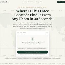
Finding a location from a photo should be straightforward, but current solutions disappoint. Google Lens returns visually similar but geographically wrong results, general chatbots confidently pinpoint places without revealing their reasoning, and once GPS data vanishes, the photo becomes a mystery. Where Is This Place addresses this friction by turning photo location identification into a transparent, verifiable process. The service accepts any image without requiring an account or signup. Users upload a photo, screenshot, or paste directly, and receive ranked candidate locations within approximately 30 seconds. The product's core differentiation lies in its commitment to reasoning transparency. Rather than offering a single confident answer, it displays the top three candidate places alongside the visual evidence that led to each ranking: architectural features, street signs, landscape characteristics, and infrastructure details. Each analysis includes a confidence label that acknowledges the limits of what the image can support, deliberately avoiding false GPS-level precision. The interface separates candidate locations from verified pins, making clear the distinction between the AI identifying a place as a likely match and having definitive evidence for an exact location. This distinction matters for users who need trustworthy answers rather than speculative ones. Users can inspect unedited model outputs, view source photos with their original licenses and documented coordinates, and verify conclusions independently on maps. The product publishes reproducible production runs rather than handwritten demos, with file hashes and independent ground-truth checks retained in reports. The platform extends beyond geolocation into privacy protection. A browser-based EXIF viewer allows users to inspect their own photo metadata before sharing, and a metadata removal tool addresses the flip side of the problem: preventing others from extracting location data from personal photos. On the free tier, users receive five analyses per week without cost. Uploaded photos are deleted within 24 hours and never used for model training. An optional paid tier unlocks deeper evidence such as exact pins and Street View comparisons when the underlying analysis supports that level of precision, though specific pricing is not disclosed. Where Is This Place targets photographers, travelers, researchers, and anyone with photos of unknown origin. The emphasis on explainable results and privacy protection positions it directly against generic AI image analysis tools, appealing to users who want to understand the reasoning behind answers, not just the answers themselves.