
Best GEO Tools Startups & Tools

Generative Engine Optimization tools for AI-powered search discovery.

Recently Listed

5 launches

Sort
Where Is This Place

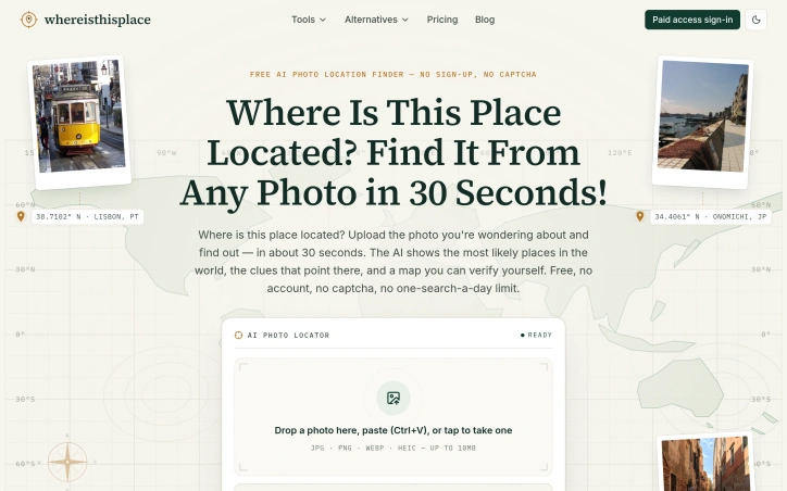
Finding a location from a photo should be straightforward, but current solutions disappoint. Google Lens returns visually similar but geographically wrong results, general chatbots confidently pinpoint places without revealing their reasoning, and once GPS data vanishes, the photo becomes a mystery. Where Is This Place addresses this friction by turning photo location identification into a transparent, verifiable process. The service accepts any image without requiring an account or signup. Users upload a photo, screenshot, or paste directly, and receive ranked candidate locations within approximately 30 seconds. The product's core differentiation lies in its commitment to reasoning transparency. Rather than offering a single confident answer, it displays the top three candidate places alongside the visual evidence that led to each ranking: architectural features, street signs, landscape characteristics, and infrastructure details. Each analysis includes a confidence label that acknowledges the limits of what the image can support, deliberately avoiding false GPS-level precision. The interface separates candidate locations from verified pins, making clear the distinction between the AI identifying a place as a likely match and having definitive evidence for an exact location. This distinction matters for users who need trustworthy answers rather than speculative ones. Users can inspect unedited model outputs, view source photos with their original licenses and documented coordinates, and verify conclusions independently on maps. The product publishes reproducible production runs rather than handwritten demos, with file hashes and independent ground-truth checks retained in reports. The platform extends beyond geolocation into privacy protection. A browser-based EXIF viewer allows users to inspect their own photo metadata before sharing, and a metadata removal tool addresses the flip side of the problem: preventing others from extracting location data from personal photos. On the free tier, users receive five analyses per week without cost. Uploaded photos are deleted within 24 hours and never used for model training. An optional paid tier unlocks deeper evidence such as exact pins and Street View comparisons when the underlying analysis supports that level of precision, though specific pricing is not disclosed. Where Is This Place targets photographers, travelers, researchers, and anyone with photos of unknown origin. The emphasis on explainable results and privacy protection positions it directly against generic AI image analysis tools, appealing to users who want to understand the reasoning behind answers, not just the answers themselves.

Geo-tools
曾大发

Finding a location from a photo should be straightforward, but current solutions disappoint. Google Lens returns visually similar but geographically wrong results, general chatbots confidently pinpoint places without revealing their reasoning, and once GPS data vanishes, the photo becomes a mystery. Where Is This Place addresses this friction by turning photo location identification into a transparent, verifiable process. The service accepts any image without requiring an account or signup. Users upload a photo, screenshot, or paste directly, and receive ranked candidate locations within approximately 30 seconds. The product's core differentiation lies in its commitment to reasoning transparency. Rather than offering a single confident answer, it displays the top three candidate places alongside the visual evidence that led to each ranking: architectural features, street signs, landscape characteristics, and infrastructure details. Each analysis includes a confidence label that acknowledges the limits of what the image can support, deliberately avoiding false GPS-level precision. The interface separates candidate locations from verified pins, making clear the distinction between the AI identifying a place as a likely match and having definitive evidence for an exact location. This distinction matters for users who need trustworthy answers rather than speculative ones. Users can inspect unedited model outputs, view source photos with their original licenses and documented coordinates, and verify conclusions independently on maps. The product publishes reproducible production runs rather than handwritten demos, with file hashes and independent ground-truth checks retained in reports. The platform extends beyond geolocation into privacy protection. A browser-based EXIF viewer allows users to inspect their own photo metadata before sharing, and a metadata removal tool addresses the flip side of the problem: preventing others from extracting location data from personal photos. On the free tier, users receive five analyses per week without cost. Uploaded photos are deleted within 24 hours and never used for model training. An optional paid tier unlocks deeper evidence such as exact pins and Street View comparisons when the underlying analysis supports that level of precision, though specific pricing is not disclosed. Where Is This Place targets photographers, travelers, researchers, and anyone with photos of unknown origin. The emphasis on explainable results and privacy protection positions it directly against generic AI image analysis tools, appealing to users who want to understand the reasoning behind answers, not just the answers themselves.

Where Is This Place preview

Key features

  • Photo Upload Analysis: Users can upload any image to identify its location without requiring an account or signup.
  • Transparent Reasoning: Top three candidate locations are displayed alongside visual evidence like architectural features and street signs that support each ranking.
See full listing
MagicGEO

Merchants operating e-commerce and local service businesses face an increasingly critical visibility gap: they rank well in traditional search engines but remain virtually invisible to AI-powered search platforms like ChatGPT, Perplexity, and Google's Search Generative Experience. MagicGEO addresses this emerging problem head-on by enabling Shopify and WooCommerce store owners to gain citations—not just rankings—from AI search engines. The product tackles what amounts to a new search paradigm that traditional SEO alone cannot solve. While conventional optimization focuses on appearing in Google's index and organic results, AI search engines operate through different mechanisms. They train on web data but prioritize sources they recognize and cite directly. Small merchants, despite solid SEO fundamentals, fall outside this ecosystem because their content lacks the signals these systems rely on. MagicGEO bridges that gap through automated infrastructure changes: schema injection to add structured data, llms.txt file deployment, GEO scoring mechanisms, and built-in citation tracking to monitor visibility across multiple AI platforms. What distinguishes this entry is its recognition that the AI search opportunity has already arrived. Rather than positioning itself as a speculative bet on emerging technology, the product functions as a practical response to a concrete distribution problem merchants face today. The solution's strength lies in its simplicity—the founder emphasizes it works "in one click," suggesting the technical complexities of AI search optimization are abstracted away from users who lack the expertise to implement these changes manually. The product has reached functional maturity; the founder explicitly notes it is ready for use and already deployed across real store operations. This moves MagicGEO beyond concept validation into the phase where actual merchants are testing and relying on its citation capabilities. Being built by a solo founder adds a lean efficiency to the offering, though it also signals the current stage of business maturity. The stated business focus is distribution rather than product development. This positioning indicates confidence that the core technology solves the problem, and the challenge ahead lies in reaching enough merchants to build meaningful revenue and market presence. For Shopify and WooCommerce operators worried about their visibility in AI-powered search, particularly those in competitive local services or e-commerce niches, MagicGEO offers a focused tool that directly addresses a gap traditional SEO services have yet to fill.


Geo-tools
R
Rida ilyes

Merchants operating e-commerce and local service businesses face an increasingly critical visibility gap: they rank well in traditional search engines but remain virtually invisible to AI-powered search platforms like ChatGPT, Perplexity, and Google's Search Generative Experience. MagicGEO addresses this emerging problem head-on by enabling Shopify and WooCommerce store owners to gain citations—not just rankings—from AI search engines. The product tackles what amounts to a new search paradigm that traditional SEO alone cannot solve. While conventional optimization focuses on appearing in Google's index and organic results, AI search engines operate through different mechanisms. They train on web data but prioritize sources they recognize and cite directly. Small merchants, despite solid SEO fundamentals, fall outside this ecosystem because their content lacks the signals these systems rely on. MagicGEO bridges that gap through automated infrastructure changes: schema injection to add structured data, llms.txt file deployment, GEO scoring mechanisms, and built-in citation tracking to monitor visibility across multiple AI platforms. What distinguishes this entry is its recognition that the AI search opportunity has already arrived. Rather than positioning itself as a speculative bet on emerging technology, the product functions as a practical response to a concrete distribution problem merchants face today. The solution's strength lies in its simplicity—the founder emphasizes it works "in one click," suggesting the technical complexities of AI search optimization are abstracted away from users who lack the expertise to implement these changes manually. The product has reached functional maturity; the founder explicitly notes it is ready for use and already deployed across real store operations. This moves MagicGEO beyond concept validation into the phase where actual merchants are testing and relying on its citation capabilities. Being built by a solo founder adds a lean efficiency to the offering, though it also signals the current stage of business maturity. The stated business focus is distribution rather than product development. This positioning indicates confidence that the core technology solves the problem, and the challenge ahead lies in reaching enough merchants to build meaningful revenue and market presence. For Shopify and WooCommerce operators worried about their visibility in AI-powered search, particularly those in competitive local services or e-commerce niches, MagicGEO offers a focused tool that directly addresses a gap traditional SEO services have yet to fill.

MagicGEO preview

Key features

  • Schema Injection: Adds structured data to stores for AI search engine recognition
  • llms.txt Deployment: Deploys llms.txt files to improve visibility in AI search platforms
See full listing
Genrank

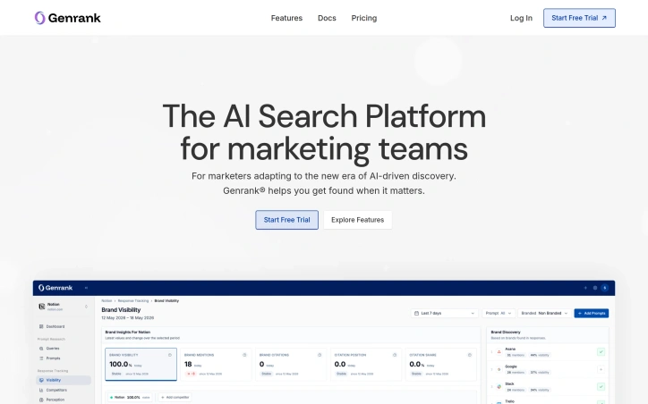
As AI language models increasingly serve as the starting point for buyer research and discovery, a gap has emerged in how brands monitor their presence in this new search frontier. Genrank addresses this directly by helping marketing teams understand and optimize how their companies appear in AI-generated responses from systems like ChatGPT. The platform recognizes that traditional search ranking, while still relevant, no longer captures the full customer journey. When potential customers engage with conversational AI to evaluate solutions or gather information, brands need visibility into whether they appear in those generated answers and recommendations. Genrank tracks this visibility across what the company frames as a "conversational funnel" distinct from keyword-based search results. The core offering includes several interconnected capabilities. Its LLM retrieval simulator shows how AI search engines chunk, retrieve, and rank content, revealing why certain brands appear prominently while others remain invisible. The platform monitors brand sentiment across news, reviews, and discussions that feed into AI recommendation systems. Its advertising insights feature surfaces which competitors are bidding on relevant prompts and what sponsored content appears alongside organic AI mentions. Content optimization tools help marketers adjust website pages and messaging to perform better within AI model retrieval processes. The social monitoring component tracks how brand perception shifts across the internet, connecting reputation signals to visibility in AI-generated answers. Genrank maintains a database exceeding 2.2 million brands, indicating established scale and reach. The platform serves multiple verticals including marketing agencies, e-commerce companies, recruitment organizations, and financial services. For agencies, it offers a competitive lever on a new dimension of visibility. For e-commerce, it addresses product discoverability in an era where price comparisons and research happen through chat interfaces. Recruitment and financial services can use the tool to become recommended options when AI systems generate career or financial guidance. Genrank targets a widening gap in the marketing technology landscape: most infrastructure was built for the age of search bars and keyword bidding. As conversational AI reshapes how people discover products and services, the platform helps teams understand and influence where and how their brands appear in these new customer conversations. The free trial model suggests accessibility for smaller teams alongside deeper offerings for enterprises.

Geo-tools
S
Siebert

As AI language models increasingly serve as the starting point for buyer research and discovery, a gap has emerged in how brands monitor their presence in this new search frontier. Genrank addresses this directly by helping marketing teams understand and optimize how their companies appear in AI-generated responses from systems like ChatGPT. The platform recognizes that traditional search ranking, while still relevant, no longer captures the full customer journey. When potential customers engage with conversational AI to evaluate solutions or gather information, brands need visibility into whether they appear in those generated answers and recommendations. Genrank tracks this visibility across what the company frames as a "conversational funnel" distinct from keyword-based search results. The core offering includes several interconnected capabilities. Its LLM retrieval simulator shows how AI search engines chunk, retrieve, and rank content, revealing why certain brands appear prominently while others remain invisible. The platform monitors brand sentiment across news, reviews, and discussions that feed into AI recommendation systems. Its advertising insights feature surfaces which competitors are bidding on relevant prompts and what sponsored content appears alongside organic AI mentions. Content optimization tools help marketers adjust website pages and messaging to perform better within AI model retrieval processes. The social monitoring component tracks how brand perception shifts across the internet, connecting reputation signals to visibility in AI-generated answers. Genrank maintains a database exceeding 2.2 million brands, indicating established scale and reach. The platform serves multiple verticals including marketing agencies, e-commerce companies, recruitment organizations, and financial services. For agencies, it offers a competitive lever on a new dimension of visibility. For e-commerce, it addresses product discoverability in an era where price comparisons and research happen through chat interfaces. Recruitment and financial services can use the tool to become recommended options when AI systems generate career or financial guidance. Genrank targets a widening gap in the marketing technology landscape: most infrastructure was built for the age of search bars and keyword bidding. As conversational AI reshapes how people discover products and services, the platform helps teams understand and influence where and how their brands appear in these new customer conversations. The free trial model suggests accessibility for smaller teams alongside deeper offerings for enterprises.

Genrank preview

Key features

  • LLM Retrieval Simulator: Shows how AI search engines chunk, retrieve, and rank content to reveal why your brand appears or remains invisible
  • Brand Sentiment Monitoring: Monitors brand sentiment across news, reviews, and discussions that feed into AI recommendation systems
See full listing
WhereWasTaken

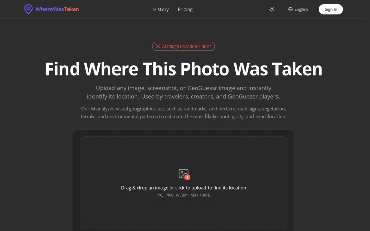
Digital detectives, travel enthusiasts, and competitive GeoGuessr players now have a dedicated tool for solving one of modern photography's central mysteries: determining exactly where an image was captured when traditional metadata trails have gone cold. WhereWasTaken addresses a genuine gap in image analysis by treating photo geolocation as a visual puzzle rather than a data-retrieval problem. Where reverse image search relies on finding identical or similar images online, this tool takes a fundamentally different approach by training its AI on geographic patterns themselves. It examines landmarks, architectural styles, road signage, vegetation types, terrain characteristics, and environmental conditions visible in a photograph to triangulate the most probable location. The product targets three distinct user groups clearly. Travelers use it to verify or understand the context of photos they've captured. Content creators benefit from identifying locations in images before sharing them. GeoGuessr players, who compete by pinpointing locations from Street View screenshots and similar imagery, find it particularly useful since those images often lack usable metadata. Several features distinguish the offering. The interface emphasizes speed and accessibility through drag-and-drop upload, handling JPG, PNG, and WEBP formats up to 10MB. The system doesn't simply output a location; it provides confidence scoring and identifies the specific visual clues that informed its prediction, giving users insight into how the AI reasoning worked. The examples displayed show real analyses with confidence percentages and demonstrate the types of landmarks the system recognizes, from iconic structures like the Eiffel Tower to regional markers like road designations in Argentina. The platform claims coverage across 56 countries and cites statistics around accuracy and volume of images processed, though these figures derive from the company's own marketing materials. The offering also expands into related functionality for viewing EXIF metadata and geotagging photos, suggesting a broader strategy around photo location intelligence. The product fills a genuine need for anyone working with decontextualized images, particularly as privacy concerns push more people toward removing location data before sharing. Whether the AI's predictions hold up in rigorous independent testing remains an important question before relying on it for professional or mission-critical use cases.

Geo-tools
L
L L

Digital detectives, travel enthusiasts, and competitive GeoGuessr players now have a dedicated tool for solving one of modern photography's central mysteries: determining exactly where an image was captured when traditional metadata trails have gone cold. WhereWasTaken addresses a genuine gap in image analysis by treating photo geolocation as a visual puzzle rather than a data-retrieval problem. Where reverse image search relies on finding identical or similar images online, this tool takes a fundamentally different approach by training its AI on geographic patterns themselves. It examines landmarks, architectural styles, road signage, vegetation types, terrain characteristics, and environmental conditions visible in a photograph to triangulate the most probable location. The product targets three distinct user groups clearly. Travelers use it to verify or understand the context of photos they've captured. Content creators benefit from identifying locations in images before sharing them. GeoGuessr players, who compete by pinpointing locations from Street View screenshots and similar imagery, find it particularly useful since those images often lack usable metadata. Several features distinguish the offering. The interface emphasizes speed and accessibility through drag-and-drop upload, handling JPG, PNG, and WEBP formats up to 10MB. The system doesn't simply output a location; it provides confidence scoring and identifies the specific visual clues that informed its prediction, giving users insight into how the AI reasoning worked. The examples displayed show real analyses with confidence percentages and demonstrate the types of landmarks the system recognizes, from iconic structures like the Eiffel Tower to regional markers like road designations in Argentina. The platform claims coverage across 56 countries and cites statistics around accuracy and volume of images processed, though these figures derive from the company's own marketing materials. The offering also expands into related functionality for viewing EXIF metadata and geotagging photos, suggesting a broader strategy around photo location intelligence. The product fills a genuine need for anyone working with decontextualized images, particularly as privacy concerns push more people toward removing location data before sharing. Whether the AI's predictions hold up in rigorous independent testing remains an important question before relying on it for professional or mission-critical use cases.

WhereWasTaken preview

Key features

  • Drag-and-Drop Upload: Accepts JPG, PNG, and WEBP formats with files up to 10MB in size.
  • Confidence Scoring: Provides confidence percentages for each location prediction.
See full listing
GeoSolver

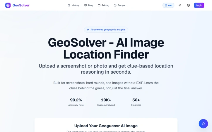
For enthusiasts of geo games and geographic analysis, manual guesswork is a thing of the past thanks to an innovative AI-powered solution. The problem it tackles is the tedious and often inaccurate process of identifying locations from images, a task that requires a deep understanding of geographic clues. This product is specifically designed for users who engage in geo games, such as Geoguessr, and need to rapidly and accurately pinpoint locations. What stands out about this solution is its ability to not only provide an answer but to explain the reasoning behind its guess. Powered by the advanced Gemini 3.1 Pro vision model, it analyzes dozens of meta clues within an image to deliver expert-level geographic analysis. With an impressive 99.2% accuracy rate in identifying the correct country, it has already been tested on over 10,000 images across 50+ countries. The level of detail it offers is remarkable, making it an invaluable tool for those looking to improve their geographic analysis skills. Key features include its capability to work with images lacking EXIF data, its systematic analysis of various geographic indicators such as road infrastructure, signage, and architecture, and its ability to provide detailed regional analysis. Users can even preview key location clues before deciding to upgrade, although full location details and complete reasoning are reserved for premium plan subscribers. By providing a learning experience rather than just a straightforward answer, this product educates users on the patterns and clues that experts rely on, effectively acting as a personal tutor for geographic analysis. The solution's focus on education and skill improvement sets it apart from being merely a 'cheat tool', instead positioning it as a serious learning aid for geo game enthusiasts.
Geo-tools
A
Andy

For enthusiasts of geo games and geographic analysis, manual guesswork is a thing of the past thanks to an innovative AI-powered solution. The problem it tackles is the tedious and often inaccurate process of identifying locations from images, a task that requires a deep understanding of geographic clues. This product is specifically designed for users who engage in geo games, such as Geoguessr, and need to rapidly and accurately pinpoint locations. What stands out about this solution is its ability to not only provide an answer but to explain the reasoning behind its guess. Powered by the advanced Gemini 3.1 Pro vision model, it analyzes dozens of meta clues within an image to deliver expert-level geographic analysis. With an impressive 99.2% accuracy rate in identifying the correct country, it has already been tested on over 10,000 images across 50+ countries. The level of detail it offers is remarkable, making it an invaluable tool for those looking to improve their geographic analysis skills. Key features include its capability to work with images lacking EXIF data, its systematic analysis of various geographic indicators such as road infrastructure, signage, and architecture, and its ability to provide detailed regional analysis. Users can even preview key location clues before deciding to upgrade, although full location details and complete reasoning are reserved for premium plan subscribers. By providing a learning experience rather than just a straightforward answer, this product educates users on the patterns and clues that experts rely on, effectively acting as a personal tutor for geographic analysis. The solution's focus on education and skill improvement sets it apart from being merely a 'cheat tool', instead positioning it as a serious learning aid for geo game enthusiasts.

GeoSolver preview

Key features

  • Image Analysis: analyzes dozens of meta clues within an image
  • Regional Analysis: provides detailed regional analysis
See full listing